Engineering news
The Geostationary Lightning Mapper (GLM) is the first lightning detector to be deployed in a geostationary orbit, according to the NOAA.
Rapid increases of lightning is a good signal that a storm is strengthening quickly and could produce a severe weather event. The GLM continually looks for lightning flashes in the Western Hemisphere so that forecasters can know when a storm is forming and provides a warning of how dangerous it could become.
For example, during heavy rain, GLM data will show when thunderstorms are 'stalled' or if they are gathering strength. This information, combined with other weather data, should help forecasters to anticipate severe weather and issue flood and flash flood warnings sooner, said the NOAA.
It could also help in dry areas, such as the western United States, to help forecasters and firefighters to identify areas that are prone to wildfires sparked by lightning.

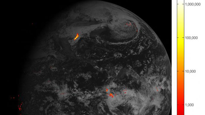
This image shows lightning data captured on February 14, 2017 over the course of an hour and displayed over an image of the Western Hemisphere from the Advanced Baseline Imager on GOES-16. Brighter colors indicate more lightning energy was recorded; color bar units are the calculated kilowatt-hours of total optical emissions from lightning.
Currently, accurate tracking of lightning and thunderstorms over oceans has been difficult for land-based radar and satellites.
NOAA spokesperson Connie Barclay told PE that the GOES-16 represents “the first major technological advancement in this area in more than 20 years”.
Barclay stressed that while published research with total lightning data indicates a high detection of severe storms in excess of 80% correct detection, that lightning alone will not generally be used by forecasters in warning decision making for severe storms. Instead it will be used in combination with radar, satellite, spotter and other information available to them. Also, the imagery is available to forecasters every minute, and the lightning data is available within 20 seconds or less.
“As forecasters gain confidence with the added insight provided by the lightning they will be able to issue warnings sooner having more situational awareness and confidence that severe storms are developing,” she added.
Big changes for forecasters
Sven-Erik Enno, a scientist at the Observations Research and Development department at the Met office, said that the advance would "change a lot" in severe weather monitoring and forecasting.
The most important improvement of the GOES-16 system is the ability to detect lightning continuously 24/7 over the Americas, explained Lorenzo Labrador, a scientist who works in satellite applications at the Met Office. "No previous satellite-based lightning sensor has been capable of doing so," he said.
This in turn allows real-time monitoring of storms over urban as well as remote areas and over the oceans, he added, which might not be under coverage of conventional ground-based lightning location systems. This could help to improve navigation safety for both aviation and mariners.
The mapper also detects in-cloud lightning, which tends to occur around five to 10 minutes before a potentially deadly cloud-to-ground-strike. This gives forecasters more time to alert people to head indoors that are in at risk areas.
Data covering all countries in North and South America transmitted by GOES-16 will available to forecasters around the world once NOAA has reached "provisional validation for operational use" at the end of May. More detailed information covering volcanic ash, fire, and cloud properties will be available around November this year.
Nasa launched GOES-R at 6:42pm EST on November 19, 2016 from Cape Canaveral Air Force Station in Florida and it was renamed GOES-16 when it achieved orbit. GOES-16 is now observing the planet from an equatorial view approximately 22,300 miles above the surface of the Earth.