In the past six months, reports have emerged of GPS jammers being used on UK roads. These small, relatively cheap portable devices send out signals that block the satellite signals needed to provide geo-location information.
So far, the devices have been used to evade the tracking systems on company cars or to steal vehicles fitted with GPS trackers. But large-scale GPS jamming could have profound effects on critical infrastructure. Ships and planes could career off course, financial systems could crash, and emergency services could be sent into disarray. Despite all the headlines screaming that an attack on GPS would bring the world to its knees, there is a little-known system running in the UK on a trial basis that could act as a back-up. Called enhanced Loran, or eLoran, the prototype system has been running in Anthorn, Cumbria, 24 hours a day, seven days a week since October 2010. The project is being led by the General Lighthouse Authorities (GLAs) and was set up to mitigate the risks of GPS jamming at sea.
Now other sectors are starting to see the potential of the system. It could one day provide an alternative method of providing the time stamps used in financial transactions and aid land-based navigation.
The eLoran system works in a similar way to GPS. A transmitter beams radio signals that are picked up by a receiver. The receiver then calculates the transmitter’s location by working out how long it has taken for the signal to travel to it.
But the qualities of the signals used in eLoran are different to those of GPS signals – eLoran uses transmitters on the earth’s surface to send out high-power, low-frequency radio signals. GPS systems, on the other hand, use low-power, ultra-high frequency signals beamed from satellites. It is the higher power levels of eLoran signals that make the system a plausible back-up to GPS, as these are less vulnerable to jamming.
Professor David Last, a consultant to the GLAs and past president of the Royal Institute of Navigation, explains: “GPS signals are almost unbelievably weak. A satellite transmits no more power than a car headlight and it illuminates nearly half the earth’s surface from 20,000km away.”
The eLoran signal is about 10,000 times stronger than this, which means that any device to jam the signal also needs to be 10,000 times stronger. “It’s like going from this tiny little sound to the biggest rock concert in the back garden – to jam it over more than a few metres means you need an installation that is definitely going to call attention to yourself,” says Last.
Loran navigation systems are nothing new. In some form or another Loran transmitters have been broadcasting signals on and off for more than 60 years. The first Loran stations were set up by the US Coast Guard in the 1940s. Subsequently, Loran became one of the most revolutionary long-range navigation aids since the invention of the magnetic compass.
The initial Loran transmitters were established in North America and the network was later expanded to Europe and the Far East. But Loran fell out of favour with the advent of GPS, and many countries, including the US, have now turned off the transmitters.


The revamped Loran system is different to the one of years gone by. Like the previous system, the signal is 100kHz and pulsed, but the specification of the pulse shape has been tightened up. The addition of a Loran data channel, known as Eurofix, means that the pulses can be modulated and data can be sent along with them.
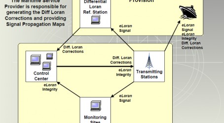
Data that is sent to ships with the signal helps to boost the accuracy of the positioning information. This is a key development over the system’s predecessor, Loran-C, and enables a vessel to establish its position with 10m of accuracy at the harbour approach. An additional differential reference station is used to get this accuracy. The differential reference station is simply a box that is connected to the eLoran transmitter via the internet. Loran receivers assume that the world is made of sea water, so the system must compensate for the fact that the signal also travels over land. As the signal travels more slowly over land, the receiver needs additional information about the propagation path to make an accurate estimate of the vessel’s position.
As the receiver cannot know the proportion of land and sea water in the path between the vessel and the transmitter, it calculates the ship’s position in two stages. First, it calculates the position based on the idea that the signals have travelled only over sea water. Next it takes into account the microsecond delays of the signal travelling over land. Data about these delays are contained in a database within the receiver.
As part of the eLoran upgrade, information about the various propagation paths at each port will be collected, integrated into the system and monitored. As these values may change over time, the reference station monitors any variations in the signals and broadcasts corrections over the internet to the eLoran transmitter, which then broadcasts the corrections to the marina through the data channel.
Another advance over previous Loran systems is in the accuracy of timing. The final version of eLoran will use three caesium clocks at each station, which will be synchronised with coordinated universal time – the standard to which clocks are regulated. Paul Williams, principal development engineer at the GLAs, says: “Now, because you have got this precise time synchronisation at each station, you can use an eLoran station just like you’d use a GPS satellite.”
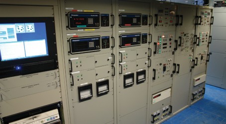
The transmitter that broadcasts the signal has had an overhaul too. Anthorn is the first Loran station to be containerised and now fits into three 40ft cargo containers. The station is monitored from Skelton 30km away, and is run by Babcock. Williams explains: “In recent months it’s been showing a 100% signal availability, and that is with a transmitter that is 20 years old.”
He adds: “We are now at the stage where we are happy with the technology.” The next phase involves rolling out eLoran to provide the UK with an initial operating capability.
This year, the GLAs began work to achieve this by installing eLoran at Dover. The system should be running there by the end of April on a trial basis. The installation of differential-Loran stations will follow by mid-2013 at six further ports – Tilbury, Felixstowe, Middlesbrough, Immingham, Grangemouth and Aberdeen. Williams explains: “The aim is that then we have a set of demonstration areas for vessels to use. We are hoping to collaborate with a ferry company and install eLoran receivers on board so we can run demonstrations and show people how effective the system is.”
It is rumoured that a decision on whether to continue with eLoran will be made by the government in 2015. If given the go-ahead, eLoran could be covering all major British ports by 2018.
Europe currently has nine Loran transmitters. Four are run by Norway, two by France, and the UK, Germany and Denmark have one each. France has already committed to running its two stations until 2020 and has done some trials with the eLoran system.
But not all countries are supportive. Williams says: “Germany and Denmark are pretty negative on Loran at the moment. The UK can’t do this alone. It’s a regional service and we rely on the continued support and interest of other countries to carry on running their signals.” No country has yet made the decision to go ahead with eLoran beyond any trial period.
Further afield, China, Russia and South Korea operate the Far East Radio Navigation System – Loran-C. South Korea is setting up an eLoran system, says Williams. Last year North Korea used jammers to block GPS signals in South Korea. Saudi Arabia is also upgrading to eLoran, and India has expressed interest, adds Williams.
In the UK, policy makers from outside the maritime domain are interested in eLoran because of its ability to transmit data and provide GPS-independent timing. “There are people getting very interested in the land mobile aspects of eLoran because you can receive the signal inside buildings, unlike GPS,” says Williams.
Potentially, eLoran can be used for applications other than marine navigation. The characteristics of the signal, such as the signal-to-noise ratio or the pulse shape, are very repeatable. This can be exploited in geo-encoding applications, to make a briefcase that can only be opened in a certain place, for example.
Prisoner tracking and tagging could also use eLoran. Currently, these systems use GPS, leaving them vulnerable to jammers. There are further potential applications in aviation where eLoran signals could be used to line up aircraft on the runway in a process known as non-precision approach or lateral navigation. This has been demonstrated in the US. As part of the upgrade, the data channel is now available for third-party access to transmit messages.
The UK is leading the way with eLoran and the technology has the potential to one day provide a much-needed lifeline in the event of an attack on GPS, says Williams.
Securing safety at sea
Other possible back-up systems for maritime GPS:
- Visual aids, such as buoys and lighthouses – reliance on GPS navigation systems means that fewer marinas are accustomed to using them these days.
- Hardening GPS: a system that uses clever antenna techniques and algorithms to beam steer the GPS receiver towards the satellite source. This can almost cancel out any jamming or interference. It is difficult, but has been used in a military environment.
- Radar absolute positioning: a radar scans and transmits pulses across the horizon that bounce off a series of passive reflectors at known locations along the coast. By picking up the pattern of reflections, vessels can map their location. This is a theoretical system for which the technology has yet to be developed.
Key dates in eLoran’s story
1940s – Loran first introduced by US Coast Guard
1994 – US Coast Guard hands over Loran facilities in Europe to host nations
2001 – US Volpe Center publishes report on GPS vulnerabilities and the dependence of critical infrastructure on the system
2004 – US Federal Aviation Administration publishes a report saying that Loran-C could be updated to create a back-up to GPS. The term enhanced Loran, or eLoran, enters the lexicon
2005 – UK General Lighthouse Authorities install a Loran-C station at Rugby, Warwickshire
2007 – Rugby station moves to site at Anthorn, Cumbria to improve coverage of the service
2010 – Broadcast of eLoran signals from Anthorn begins. US turns off Loran-C
2011 – Work begins on rolling out eLoran to seven ports on the east coast of the UK. Experts find evidence that GPS jammers are being used on UK roads
2015 – Decision expected from the government on whether to develop eLoran for every UK port by 2018